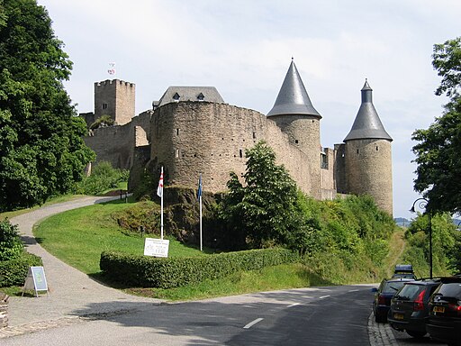
Burg Bourscheid
Burg Bourscheid is one of the most prominent medieval hilltop castles in Luxembourg, dominating the Sûre (Sauer) valley from its exposed limestone promontory. The ensemble presents a long stratigraphy of defensive, residential, and economic architecture spanning roughly the 10th to the 18th centuries, with large-scale 20th-century restoration that returned much of the visible masonry to a coherent, legible state. This article provides a technical, architecturally focused analysis of the castle: its site, materials, defensive systems, internal organisation, structural dimensions, later alterations, and current conservation strategy.
Historical Development
Origins and Early Phases
Burg Bourscheid originated as a small fortification in the early medieval period, probably in the 10th or 11th century, taking advantage of the isolated limestone ridge for natural defence. The early phase consisted of timber and earthworks later replaced by masonry. Expansion in the High Middle Ages transformed the site into a multi-enclosure stone castle with a bergfried (keep), curtain walls, and a residential complex.
High and Late Medieval Growth
Between the 12th and 14th centuries the castle saw its most significant enlargement: outer baileys were added, the inner ward was consolidated with thick stone walls, and domestic structures—great hall, chapel, kitchen—were formalised. Architectural features from this period include Romanesque masonry techniques transitioning to early Gothic fenestration and vaulting in service and liturgical spaces.
Early Modern Decline and 20th-Century Restoration
Like many regional fortifications, Burg Bourscheid lost military relevance by the 17th–18th centuries and entered phases of neglect and partial ruin. Extensive restoration undertaken during the 1930s and again after World War II stabilised and partially reconstructed collapsed masonry, consolidated foundations, and adapted parts of the castle for tourism while aiming to preserve visible historic fabric.
Site and Topography
Location and Strategic Position
- Site siting: Promontory of Middle Devonian limestone above a pronounced meander of the Sûre river.
- Elevation: Castle platform ranges between approximately 300 to 320 meters above mean sea level; river level in the valley is around 180–200 meters, giving a vertical separation of roughly 100–140 meters.
- Visibility: 270-degree visual control over the valley approach; natural escarpments on three sides reduce need for extensive artificial outer defences.
Geology and Foundations
- Bedrock: Carbonate platform limestone with competent bedding planes, providing solid bearing strata for spread footings and cut rock foundations.
- Excavation behaviour: Limestone allows direct bedrock cutting for stepped foundations and rock-cut cisterns; however, bedding discontinuities require careful joint treatment to avoid preferential water paths.
- Subsurface drainage: Natural outfalls towards the river; historic builders exploited rock drains and soakaways where bedrock permitted percolation.
Architectural and Structural Details
Overall Plan and Zoning
- Enclosure structure: Multiple concentric wards—inner ward (upper bailey) containing the bergfried and main residential range; middle ward containing service buildings and courtyard; outer ward providing additional defensive buffer with access control features.
- Circulation: Primary access from the terrace and valley side via a single controlled approach incorporating a gatehouse and drawbridge in earlier phases; service access to kitchens and cellars oriented towards the protected rear courtyards.
Defensive Systems
Curtain Walls and Parapets
- Wall thickness: Inner curtain walls typically 1.6–2.2 meters at ground level, tapering higher; outer baileys often 1.0–1.5 meters.
- Wall heights: Retained sections indicate heights in the range 6–12 meters depending on the location and era of construction.
- Parapet features: Crenellations and walking galleries originally present; surviving segments show queen-posted timber walkways and corbelled machicolation traces.
Bergfried (Keep)
- Form: Cylindrical or slightly tapering tower typical of the region, acting as observation point and last refuge.
- Dimensions: Surviving plans and sections suggest a diameter of 8–11 meters with wall thickness at base 2.0–2.8 meters and vertical height intact of 15–20 meters for extant masonry.
- Internal access: Narrow spiral stairway embedded within the wall thickness, small slit windows for light and defense.
Gatehouse and Access Control
- Gate structure: Multiple defensive layers including a foregate, gate passage with murder holes, and a portcullis groove in remaining masonry.
- Drawbridge and moat: Original moat was rock-cut on the vulnerable approach side; historic timber drawbridge spans of 4–7 meters were used to close the approach.
Domestic and Service Buildings
Great Hall and Residential Range
- Great hall dimensions: A principal hall of approximately 12–16 meters in length and 6–8 meters in width, with evidence of a raised dais and fireplace or heated bench.
- Floors and roofing: Two-storey residential blocks with timber joists and later replacement roof trusses; roofing originally stone slate or clay tile depending on material availability.
- Heating and sanitation: Centralised hearths in public rooms; garderobes projecting into the outer wall or into shafts leading to cesspits; archaeological evidence of flue-lined ovens and kitchen hearths.
Chapel and Liturgical Spaces
- Chapel placement: Typically located within the inner ward or attached to the residential block; a narrow east-west orientation with small lancet windows.
- Vaulting: Choir and sanctuary may retain ribbed vaults or pointed barrel vaulting in later medieval upgrades.
Cellars, Cisterns and Storage
- Subterranean features: Rock-cut cellars and cisterns for water supply and storage, with vaulted stone roofing to control humidity.
- Capacity: Cistern volumes estimated in the hundreds to low thousands of liters depending on cut dimensions; cellars sized for barley, grains and wine tithes.
Materials and Masonry Techniques
- Primary stone: Locally sourced Middle Devonian limestone for ashlar facing and rubble fill.
- Masonry composition: Ashlar quoins and dressings with coursed rubble infill bonded with lime mortar; selective use of harder sandstone for sills and thresholds.
- Mortar: Traditional lime-based mortars with hydraulic additives in later repairs to increase early strength where exposure was high.
Structural Condition, Restoration and Conservation
Deterioration Mechanisms
- Weathering: Freeze-thaw cycles causing spalling in weather-exposed beds; biological colonisation (mosses and lichen) trapping moisture against stone surfaces.
- Moisture ingress: Rising damp in lower wall courses, water penetration from failed roof coverings, and preferential flows along bedding planes in the limestone.
- Historical repairs: 19th–20th century repointing used cement-based mortars in some campaigns, causing incompatibility and accelerated decay of adjacent softer stone.
20th-Century Interventions and Stabilisation
- Consolidation works: Repointing with compatible lime mortars, insertion of stainless steel anchors in fractured zones, and grouting of cavities with lime-based grout to re-establish load paths.
- Rebuilt elements: Partial reconstruction of collapsed wall crowns and battlements using identifiable modern mortar and discrete ashlar to distinguish repair from original fabric.
- Access and safety: Installation of interpretive walkways, safety railings, and controlled visitor routing to limit wear to vulnerable masonry.
Ongoing Conservation Strategy
- Monitoring: Crack gauges on vaulted elements and tiltmeters on key towers; scheduled photogrammetric surveys to detect volumetric changes in masonry.
- Moisture control: Improving roof coverings with breathable underlays, reinstating traditional lead flashings and discreet guttering to reduce run-off onto uprights.
- Material compatibility: Avoidance of cement mortars, specification of hydraulic lime for exposed joints, and selective replacement of eroded ashlar with matching petrological units.
- Reversibility principle: New interventions designed to be removable without damaging historic masonry, and modern services run in secondary spaces away from primary fabric.
Use, Interpretation and Visitor Management
Adaptive Reuse and Public Presentation
- Access programme: The site is maintained as an educational and tourist destination with guided tours, interpretive panels, and periodic cultural events that utilise the great hall and open courtyards.
- Exhibition strategy: Displays focus on construction techniques, defensive architecture, and the castle’s role in regional transport and economy.
- Safety and circulation: Routes engineered to prevent concentrated loading on fragile vaults; temporary structures are avoided on historic floor slabs.
Community and Research Integration
- Archaeological investigations: Controlled trenches and targeted excavations inform phasing, identify buried features such as postholes and earlier timber revetments, and guide restoration priorities.
- Skills training: Stone masonry and lime mortar conservation workshops run on site to develop local conservation expertise and ensure continuity of craftsmanship.
Conclusion
Burg Bourscheid is a technically rich example of a river-valley hill castle whose surviving fabric records medieval defensive thinking, domestic arrangements, and adaptive responses to environment and decline. Its solid limestone foundations and layered masonry show why the site persisted through centuries, while modern conservation emphasises material compatibility, structural monitoring, and reversible repair to preserve both fabric and meaning. Continued archaeological research, controlled visitor management, and investment in specialist conservation skills are essential to retain Burg Bourscheid as a stable, legible, and accessible monument for future generations.
