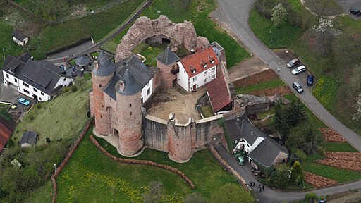
Bertradaburg
Bertradaburg is a hilltop castle ruin located above the village of Kordel in the Eifel region of western Germany. Erected on a volcanic basalt spur, the site displays architectural phases from the early medieval period through late Gothic modifications. Today it stands as a well-preserved example of strategic site selection, defensive innovation, and modern conservation practice.
Historical Development
Early Foundation and Carolingian Connections
The castle’s origins date to the 10th century, when a wooden stronghold was established to control traffic along the Kyll River valley. Its name commemorates Bertrada, mother of Charlemagne’s father, hinting at Carolingian patronage or legendary association. By the late 11th century, masonry construction replaced earlier timber palisades.
High Medieval Expansion
In the 12th and 13th centuries, Bertradaburg underwent significant enlargement. The original keep was heightened and refaced in local basalt ashlar. A surrounding curtain wall and an outer bailey with workshops and stables were added to support a growing garrison and administrative staff.
Late Gothic and Postmedieval Adaptations
Between the 14th and 16th centuries, the castle’s residential quarters were modernized. Larger windows with pointed arches and decorative tracery appeared in the lord’s hall. A chapel was inserted into the inner ward. After the Thirty Years’ War, the fortress fell into partial ruin and saw only minor repairs before 19th-century interest in Romantic ruins spurred initial stabilization.
Site and Topography
Location and Strategic Position
- Elevation: 375 meters above sea level
- Vertical prominence: ~120 meters above the Kyll River valley floor
- Field of view: approximately 280 degrees of visibility over river approach routes and adjacent high ground
Bertradaburg occupies a narrow basalt ridge, offering defensible slopes on three sides and a single accessible spur toward the northeast where gate works were concentrated.
Geology and Foundation Conditions
- Bedrock: Columnar basalt flows of Middle Devonian volcanic origin
- Foundation method: Direct setting of ashlar footings on quarried basalt ledges; minimal leveling cut into natural bedrock
- Drainage: Historic rock-cut channels divert surface water to dry moats and cistern inlets
The use of basalt provided extraordinary compressive strength for walls, but required precise dressing to achieve stable courses.
Architectural and Structural Details
Layout and Zoning
Outer Bailey and Curtain Wall
- Enclosure area: ~1,800 m²
- Wall thickness: 1.2–1.6 meters at base, tapering to 1.0 meter at parapet level
- Height: 6–9 meters surviving masonry
The outer bailey contained workshops, a smithy, and fodder storage. A gatehouse flanked by semicircular bastions controlled the single approach.
Inner Ward and Keep
- Inner ward area: ~800 m²
- Keep (Donjon) dimensions: square plan of 8 × 8 meters
- Keep height: originally 20–22 meters, current ruin stands at 16 meters
- Wall thickness at base: 2.5 meters
The keep’s robust walls housed storage on ground level, a lord’s chamber on the first floor, and a roof platform for observation and signaling.
Gatehouse Complex
- Drawbridge span: 5.5 meters over rock-cut ditch
- Portcullis groove: cut into basalt shear face
- Murder holes: two aligned over entrance passage
A barbican with arrow slits extended defense outward, channeling attackers into a narrow killing zone.
Defensive Features
Curtain Walls and Parapets
- Crenellations: alternating merlons and embrasures; merlon width 1.2 meters, embrasure width 0.8 meters
- Walkway width behind parapet: 1.2 meters, surfaced with dressed basalt slabs
Flanking Towers
- Number: three projecting towers along inner curtain
- Tower diameter: 6–7 meters
- Height: 12–14 meters
- Wall thickness: 1.8 meters at base
These towers allowed enfilade fire along the wall faces and protected blind spots.
Domestic and Service Areas
Great Hall and Residential Quarters
- Great hall dimensions: 10 × 8 meters internal
- Ceiling height: 5.5 meters with surviving springer stones for former timber roof trusses
- Fireplace remains: hearth width 1.4 meters with flue leading into wall void
The hall incorporated latrine chutes in an adjoining projection, discharging into a vaulted service corridor.
Chapel
- Dimensions: 6 × 4 meters internal
- Architectural style: late Gothic pointed arch window with tracery reopening in 15th century
- Vaulting: ribbed stone vault with central keystone
The chapel stood against the south curtain wall, lit by a single large window overlooking the valley.
Cellars and Cisterns
- Cistern capacity: ~12,000 liters, cut into bedrock beneath keep platform
- Cellar vault: semicircular barrel vault, 2.5 meters clearance, used for wine and grain storage
A network of subfloor channels directed rainwater from roof drains into the cistern.
Materials and Masonry Techniques
- Primary stone: locally quarried columnar basalt for ashlar and rubble fill
- Mortar: lime-based binder with crushed basalt aggregate
- Dressing: bossed basalt blocks with lightly hewn edges to ease mortar joints
Fine tooling marks remain on dressed blocks, indicating skilled medieval stonemasonry.
Conservation and Restoration
Deterioration Mechanisms
- Basalt weathering: surface exfoliation from freeze-thaw
- Mortar fatigue: shrinkage cracks in repairs made with cementitious mixes in the 19th century
- Vegetation growth: ivy and moss trapping moisture against masonry
20th- and 21st-Century Interventions
- Repointing with NHL (natural hydraulic lime) mortars matched to original compressive strength
- Installation of discreet stainless steel anchors bridging fractured stones
- Reconstruction of collapsed cornices using numbered replacement blocks for reversibility
- Roof canopy over keep reduces water impact on upper courses
Ongoing Maintenance Strategy
- Annual condition surveys with photogrammetric mapping of crack propagation
- Controlled removal of invasive vegetation and biological growth
- Periodic testing of mortar porosity and stone moisture content using resistance probes
- Drainage improvements: relining historic cut channels and adding French drains outside curtain wall foundations
Public Access and Interpretation
Visitor Facilities
- Path network: stabilized basalt paving with handrails where slope exceeds 15 degrees
- Information panels: technical diagrams of the keep’s structural evolution and original roof truss design
- Viewing platform: steel-frame deck cantilevered off inner wall for 360-degree panorama
Educational and Cultural Programmes
- Medieval craft workshops: live demonstrations of basalt dressing and lime mortar mixing
- Historical re-enactments: using the great hall and barbican for small-scale events
- Research partnerships: collaboration with the University of Trier for archaeological and structural analyses
Conclusion
Bertradaburg exemplifies the intelligent use of volcanic geology for defensive architecture and presents a continuous narrative from early medieval fortification to modern conservation practice. Its basalt ashlar and robust curtain walls illustrate regional resource utilization and technical craftsmanship. Current stewardship balances meticulous structural monitoring, compatible repair methods, and engaging public interpretation to ensure that this landmark endures as both a historic monument and an educational resource.
