Antonov An-30
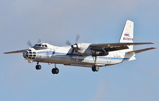
The Antonov An-30 is a specialized derivative of the An-24 twin-turboprop transport, optimized for aerial cartography and survey missions. Its most distinctive feature is the extensively glazed, elongated nose housing vertically and forward-looking cameras. Developed in the late 1960s by the Antonov Design Bureau, the An-30 first flew in 1967 and entered service in the early 1970s, fulfilling mapping requirements across Eastern Europe, Asia, Africa, and Latin America.
With robust STOL characteristics inherited from the An-24 platform, the An-30 combines high-altitude photographic capability with the flexibility to operate from short or unpaved strips. More than 100 airframes were produced, many of which remain in use today for geological reconnaissance, forestry monitoring, and urban planning surveys.
Design and Development
Origins and Mission Profile
The An-30 program originated from a Soviet need to standardize photo-survey operations on a versatile airframe. By lengthening the An-24 fuselage and reconfiguring the nose section, Antonov created an aircraft capable of carrying an array of metric, panoramic, and multispectral cameras. Dedicated racks and power supplies allow quick interchange of optical, infrared, and laser terrain-profiling instruments.
A reinforced cabin floor supports heavy camera mounts and mission consoles. Large side windows enable visual observation, while a dedicated darkroom locker stores film magazines. Pressurization at survey altitudes up to 6,500 meters ensures crew comfort and camera film stability.
Airframe and Structure
The An-30 retains the high-wing, braced monoplane layout of its An-24 progenitor but features an elongated forward fuselage. The glazed nose structure comprises bullet-resistant glass panels and structural framing designed to minimize distortions in imagery. Wing dihedral of 2° enhances lateral stability during low-speed photographic runs.
Landing gear is of the fixed-strut, inward-folding type, with wide-track bungee-suspended main units and a steerable nose wheel. Low-pressure tires and extended oleo struts allow operations over rough terrain. The airframe utilizes primarily riveted aluminum alloys, with steel reinforcement around camera apertures.
Aerodynamics and STOL Characteristics
Optimized for stable, low-speed flight, the An-30 employs leading-edge slats and double-slotted Fowler flaps. Slats deploy automatically below 200 km/h to maintain lift margin during survey runs. Flaps extend up to 40° for steep approaches and short-field landings. A large vertical tail with dorsal fin fillet ensures yaw stability at high altitudes.
Wing fences reduce spanwise flow and improve lift distribution during camera-run maneuvers. The stall speed with full flaps is 120 km/h, while stall buffet is mild and predictable, enhancing safety during low-altitude operations.
Powerplant and Performance
Engines
Two Ivchenko AI-24VT turboprop engines power the An-30, each rated at 2,820 shp. They drive four-blade reversible-pitch propellers for improved braking on landing rolls. Dual-channel FADEC systems manage fuel scheduling, while full-authority propeller governors maintain optimum blade angle for climb, cruise, and descent profiles.
Each engine feeds an integrated oil-cooler-and-heater system to guarantee reliable starting in sub-zero temperatures. Auxiliary power units are available for ground operation of camera equipment and environmental controls.
Flight Performance
- Maximum speed at sea level: 555 km/h
- Cruise speed at 6,000 m: 500 km/h
- Range with standard tanks: 2,400 km
- Service ceiling: 8,000 m
- Takeoff distance to 15 m obstacle: 1,230 m
- Landing distance from 15 m obstacle: 835 m
High-altitude cruise enables wide-swath photographic coverage, while the excellent climb rate—8 m/s at MTOW—reduces transit time to survey altitudes.
Avionics and Mission Equipment
Aerial Survey Suite
The core of the An-30’s mission capability lies in its precision camera systems. A rotating carousel mount in the nose houses up to three metric cameras, switchable in flight. Panoramic strip cameras and vertical-axis frame cameras can operate simultaneously, each with their own gyro-stabilization platform and film magazine.
Dedicated forward-looking infrared sensors and downward-looking laser altimeters provide real-time terrain profiling. Onboard darkroom facilities allow immediate film development and initial quality assessment before landing.
Navigation and Communications
A full IFR avionics suite supports precise route following over remote regions. Dual VOR/ILS receivers, DME, ADF, and TACAN enable radial-based navigation, while an integrated INS/GPS system ensures centimeter-level positional accuracy for photo-georeferencing.
Communications include UHF/VHF radios with SELCAL, satellite link data downlink for mission telemetry, and an emergency ELT. A cockpit-mounted multi-function display consolidates flight, engine, and survey data.
Variants and Special Configurations
- An-30: Standard aerial survey model with metric cameras and basic avionics
- An-30A: Upgraded navigation suite with dual INS/GPS and digital mapping console
- An-30M: Maritime patrol derivative fitted with search radar and magnetic anomaly detector
- An-30U: Unpressurized variant for VIP transport or parachute training
- An-30RV: Aeromedical version equipped with patient stretchers and life-support systems
Custom mission kits include environmental-monitoring sensors, bush-fire infrared scanners, and geophysical magnetometers.
Operational History
Entering service in 1970, the An-30 quickly became the backbone of Soviet and Warsaw Pact mapping programs. Export customers in India, Cuba, and Angola used the type for topographic charting and mineral exploration. During the Soviet era, the type surveyed over 15 million square kilometers of territory.
In the post-Cold War period, many An-30s transitioned to civilian firms conducting forestry management in Canada and mining surveys in Africa. Continued airframe support and avionics upgrades have kept the fleet active well into the 2020s.
Technical Specifications
| Parameter | Specification |
|---|---|
| Crew | 6 (2 pilots, navigator, systems operator, 2 camera technicians) |
| Capacity | Up to 5 mission specialists |
| Length | 23.53 m |
| Wingspan | 29.20 m |
| Height | 7.42 m |
| Wing area | 70.4 m² |
| Empty weight | 15,900 kg |
| Maximum takeoff weight | 24,000 kg |
| Powerplant | 2 × Ivchenko AI-24VT turboprops, 2,820 shp each |
| Maximum speed | 555 km/h |
| Cruise speed | 500 km/h |
| Stall speed (flaps down) | 120 km/h |
| Range | 2,400 km |
| Service ceiling | 8,000 m |
| Takeoff distance (15 m obstacle) | 1,230 m |
| Landing distance (15 m obstacle) | 835 m |
Beyond its core survey mission, the An-30 remains a platform for emerging technologies such as real-time digital photogrammetry and unmanned aerial vehicle mothership operations. Future upgrades may include hybrid-electric auxiliary propulsion and high-resolution multispectral lidar arrays. For mapping professionals and aviation enthusiasts alike, the Antonov An-30 continues to symbolize adaptability and precision in aerial reconnaissance.
